MIDDLE BRONZE AGE I (2000-1800 BC)
Although current evidence suggests the founding of the city may go back to the last centuries of the Early Bronze Age, around 2200 BC, this earliest occupation remains elusive. In the Amuq Valley, the Early-Middle Bronze Age transition is still not well understood, due to the fragmented nature of the archaeological data between the two major Bronze Age tell sites: Tell Atchana (Middle and Late Bronze) and Tell Tayinat (Early Bronze). At the nearby Tell Mardikh (Ebla, in modern Syria), a late Early Bronze Age text from Palace G refers to a dependent city called A-la-la-ḫu-um, likely associated with Alalakh. This textual evidence may be correlated with the Early Bronze Age remains at Tell Tayinat, as Tell Atchana has revealed no Early Bronze IVA (2500–2300 BC) remains contemporary to the Tell Mardikh (Ebla) Palace G . This suggests that the heart of the city moved, yet the name continued to be used in the Middle and Late Bronze Ages.
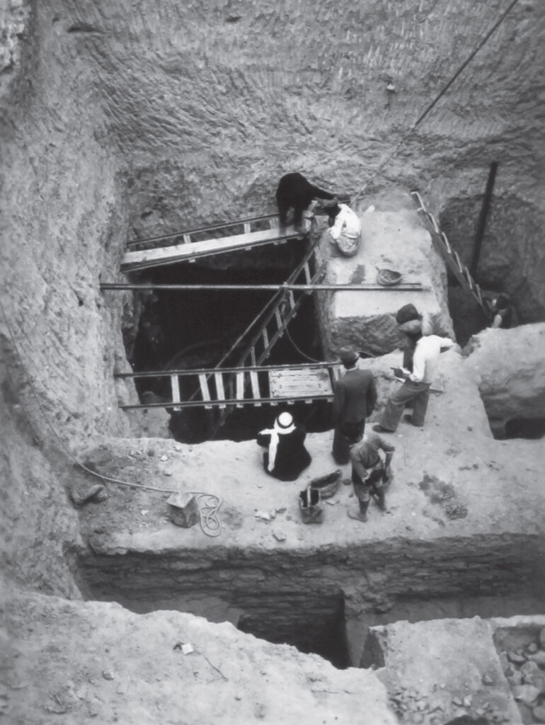
At Tell Atchana, except for the broad-scale horizontal exposure of the late Middle Bronze II monumental Level VII Palace, temple, and gate complex, the Middle Bronze remains have only been uncovered in several small soundings, and their stratigraphic and chronological correlations were left ambiguous in Woolley’s final publication (1955). The stratification pit that he dug through the southern end of the Level VII Palace reached 13.75 m below the top of the mound. The excavation area became progressively smaller due to the depth and the difficulty of removing soil, which was further complicated by the high water table, and Levels XVI–XIV were investigated only in 10 × 8 m exposures. Level XVII, the earliest Level identified by Woolley, was not explored, since it was under water. The stratification pit, the temple sounding, the Level IV Palace soundings, and the Site H and Trench F excavations generated data for the Middle Bronze but with limited exposures. Today, the temple sounding resembles a meteor crater, partially filled with decayed mudbrick detritus, and is visible down to Level XVI, revealing an uninterrupted sequence of temples. Unfortunately, the limited documentation from the Middle Bronze soundings, the absence of elevation data, and the inaccessible field records have made necessary the complicated task of re-exploring Woolley’s Middle Bronze stratigraphic sequence. This work is more complex due to the long, steady, and slow-changing nature of the material culture, often creating difficulties in defining index markers for chronological implications. Nevertheless, the earliest levels encountered in the temple sounding point to the presence of monumental architecture, reflecting signs of a well-organized administrative system indicative of urbanization.
1947
Courtesy of University College London, Institute of Archaeology
1947
Courtesy of University College London, Institute of Archaeology
At Tell Atchana, except for the broad-scale horizontal exposure of the late Middle Bronze II monumental Level VII Palace, temple, and gate complex, the Middle Bronze remains have only been uncovered in several small soundings, and their stratigraphic and chronological correlations were left ambiguous in Woolley’s final publication (1955). The stratification pit that he dug through the southern end of the Level VII Palace reached 13.75 m below the top of the mound. The excavation area became progressively smaller due to the depth and the difficulty of removing soil, which was further complicated by the high water table, and Levels XVI–XIV were investigated only in 10 × 8 m exposures. Level XVII, the earliest Level identified by Woolley, was not explored, since it was under water. The stratification pit, the temple sounding, the Level IV Palace soundings, and the Site H and Trench F excavations generated data for the Middle Bronze but with limited exposures. Today, the temple sounding resembles a meteor crater, partially filled with decayed mudbrick detritus, and is visible down to Level XVI, revealing an uninterrupted sequence of temples. Unfortunately, the limited documentation from the Middle Bronze soundings, the absence of elevation data, and the inaccessible field records have made necessary the complicated task of re-exploring Woolley’s Middle Bronze stratigraphic sequence. This work is more complex due to the long, steady, and slow-changing nature of the material culture, often creating difficulties in defining index markers for chronological implications. Nevertheless, the earliest levels encountered in the temple sounding point to the presence of monumental architecture, reflecting signs of a well-organized administrative system indicative of urbanization.
Indirectly, the signs of a strong administrative system are also evident in the recent excavations conducted at the peripheral site of Toprakhisar Höyük in the Altınözü highland, located roughly 10 km from Alalakh. The presence of an administrative building there, dated to the early 20th century BC, is regarded as linked to olive oil and wine production that textual records found at Tell Atchana reveal operated under the management of the kings of Alalakh. According to recent sedimentary corings conducted around Tell Atchana, a significant increase in agricultural activities during the Middle Bronze may be indicated by the documented charcoal intensity. Thus, intra- and offsite data confirm that the Amuq Valley and its surroundings benefited from various aspects of urbanization at the beginning of the Middle Bronze.